Southern Corsica, ce n'est pas only beaches. It is also one of the finest walking grounds in the Mediterranean : a coast carved by the wind, scented maquis, laricio pine forests, granite needles. And from our villas in Figari, most of the south's finest paths are less than thirty minutes' drive away. Here is our selection, tested season after season.
Before you go: the basics
- Best season — April to early June, then mid-September to October. In July and August, set off before 8 a.m. or after 5 p.m. to avoid the crushing heat.
- Footwear — walking or trail shoes are essential. Corsican paths are stony, and the granite can be smooth and slippery.
- Water — at least 1.5 litres per person in summer. There is no water on most of these paths.
- Hat and sun cream — most coastal paths face due south, with no shade.
- Fire risk — check the alert map on corse.gouv.fr. Some paths close when the risk is high.
“The real Corsican luxury is finishing a walk with your feet in the sea, then going home for a dive into the pool.”
— Logbook
Our selection, from nearest to furthest
Distances are given from Les Hameaux de Buttaciolo in Figari.
RANDONNÉE 01 · 5 MIN DES VILLAS
The path of Canni
The walk on the hamlet's doorstep, through the Sotta maquis.
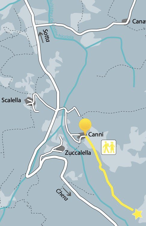
The path starts at the hamlet of Canni, between Sotta and the villas. A quiet walk through the most genuine Corsican maquis, past pastoral ruins, century-old cork oaks and dry-stone shepherds' huts. Ideal at the start of a stay, to get to know the maquis before tackling something more ambitious.
The walk ends gently — no spectacular panorama, but the feel of a real piece of Corsican countryside, fifteen minutes on foot from the villa.
— Our advice
Do it early (before 9 a.m.) to hear the birds and avoid the heat. A well-marked loop; no risk of getting lost.
RANDONNÉE 02 · 15 MIN DES VILLAS
The path ofs douaniers, de Figari à Ventilegna
The emblematic coastal walk of the south — coves, pink granite, translucent water.
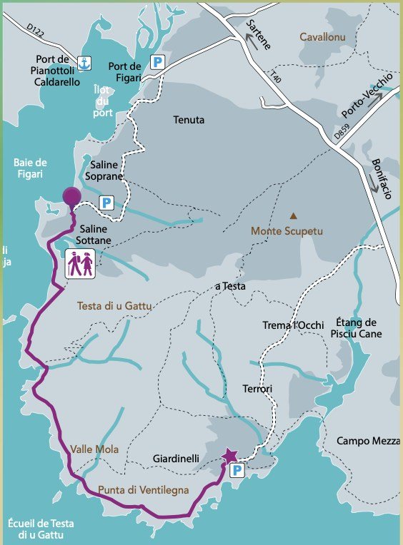
The great coastal walk. Starting at Saline Sottane on the bay of Figari, heading due south along the shore. The path crosses the maquis on a balcony above the sea, with wonderful coves that are entirely deserted where you can stop and swim. The end point is the Punta di Ventilegna, with its Genoese tower and the wild beach of Giardinelli.
C'est la coastal walk that anyone who enjoys walking should do at least once. Quiet compared with the Bruzzi, yet just as spectacular. You can return the same way or leave a car at the Giardinelli car park.
— Our advice
Bring a swimsuit and towel: the coves along the way are irresistible. Allow 2 litres of water each; there is nowhere to restock.
RANDONNÉE 03 · 15 MIN DES VILLAS
The path ofs Bruzzi
“A day in paradise” — that is what every walker says. Our favourite for a first outing.
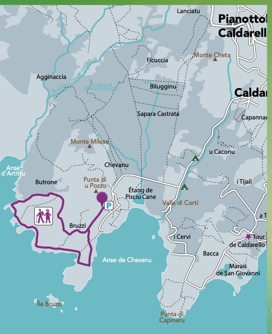
Set within the Bouches de Bonifacio Nature Reserve, in the parish of Pianottoli-Caldarello, this path is probably the most photographed in Southern Corsica — with reason. An easy loop through dense maquis opening onto improbable coves, with taffoni granite blocks carved by the centuries and a sea of frankly unreal turquoise.
The going is sandy and stony but within everyone's reach. Every cove invites a swim — it is one of the few walks where you can genuinely plan to stay all day, with a picnic and a snorkel.
— Our advice
Very little shade — avoid midday to 3 p.m. in summer at all costs. Arrive early, around 8.30, to have the coves to yourself.
RANDONNÉE 04 · 30 MIN DES VILLAS
L'Omu di Cagna
The rock that symbolises Southern Corsica — for fit walkers.
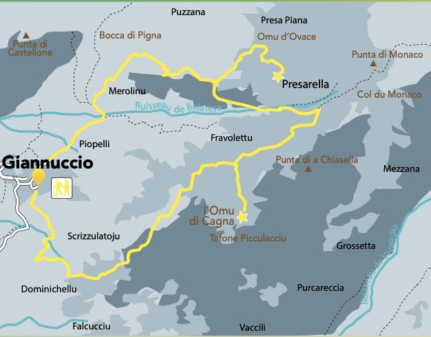
The rock known as theOmu di Cagna ("l'homme de Cagna") is visible from all over Southern Corsica, a giant human silhouette perched on its summit. Reaching it is la the legendary walk of the south, for fit walkers only: more than 1,100 metres of ascent, six hours there and back, and at the end an easy scramble to reach the base of the rock.
It starts from the hamlet of Giannuccio. The path climbs steadily through the forest before opening onto an astonishing rock plateau. The summit view takes in the whole of Southern Corsica, as far as Sardinia on a clear day.
— Our advice
A 6.30 a.m. start is essential in summer. At least 3 litres of water. Boots with ankle support are compulsory. Do not attempt it in stormy weather — the summit is dangerously exposed.
RANDONNÉE 05 · 25 MIN DES VILLAS
La Rondinara bay
The finest beach in Corsica, seen from above. The family walk par excellence.
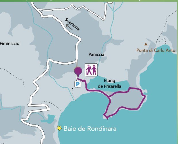
A short family loop (under an hour) around the Rondinara peninsula. From the car park near the Prisarella lagoon, five minutes of gentle climbing brings you to the top of the peninsula (53 m), with a 360° view over the perfectly round bay and its orange-red rocks against the blue of the sea.
The ideal combination: the walk in the morning, then the beach all afternoon. Rondinara remains, to our mind, the finest beach in Corsica — a perfectly circular lagoon, white sand, shallow, ideal for children.
— Our advice
Paid parking in summer (€6–8 a day). Arrive before 10 a.m. in July and August: the bay fills quickly. Bring a mask and snorkel, the water is crystal clear.
RANDONNÉE 06 · 25 MIN DES VILLAS
De Palombaggia à Pruna
A little-known coastal walk behind the most famous beach in Corsica.
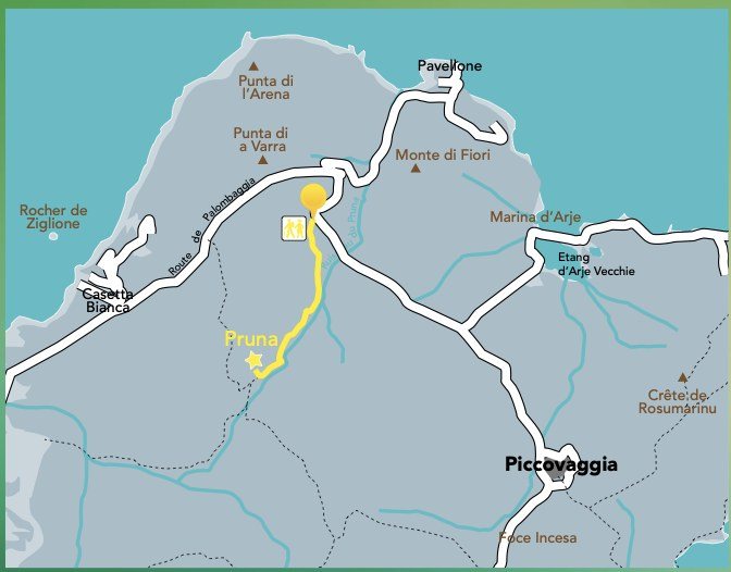
Little known, this short walk starts from the Palombaggia road and heads into the maquis through century-old umbrella pines. It offers another reading of Palombaggia, far from the crowds on the beach. Superb views over the bay, the Cerbicale islands and the inland peaks.
Combine it with a morning on the beach: the walk late morning, then a picnic and a swim in the afternoon.
— Our advice
Parking along the Palombaggia road is full in summer. Arrive before 9 a.m. or after 4 p.m. Avoid weekends in July and August.
RANDONNÉE 07 · 25 MIN DES VILLAS
De Tamariccio à la Punta di Colombara
Petite boucle côtière entre pins parasols et rochers rouges.
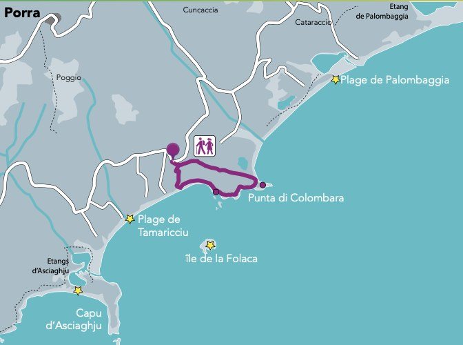
The path leaves the car park behind Tamariccio beach and loops round to the Punta di Colombara, with a plunging view over the island of Folaca. Sections between umbrella pines and rocks, hidden coves reachable halfway along, and a panorama over the whole bay of Santa Giulia.
One of the few walks where you can take in two different beaches in one day: Tamariccio before the walk, Palombaggia after.
— Our advice
A good family option with children from about six. Parking at Tamariccio is paid in summer (€5).
RANDONNÉE 08 · 25 MIN DES VILLAS
Vers la Tour d'Olmeto
A Genoese tower at the end of a wild coastal path.
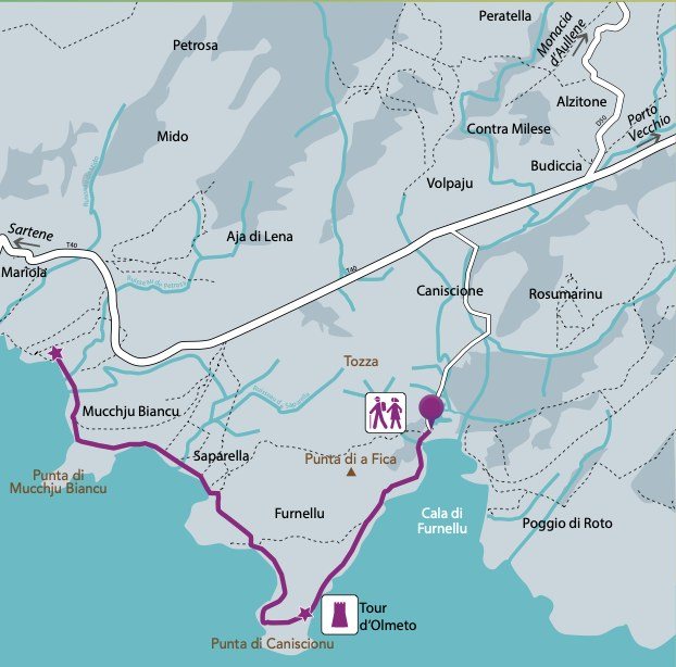
From the hamlet of Caniscionu, heading due south to the Tour d'Olmeto, a sixteenth-century Genoese tower set on its promontory facing the sea. The path crosses a particularly fragrant maquis (immortelle, myrtle, rock rose), with sections on a balcony above the water.
Quiet compared with the neighbouring Bruzzi, this walk offers the same wild beauty without the crowds. You can swim at Cala di Furnellu halfway along.
— Our advice
The path is only lightly waymarked — download the GPX track before you go (Visorando or IGN Rando). Be careful in summer: no shade at all.
RANDONNÉE 09 · 30 MIN DES VILLAS
La boucle de Peratella
A walk in the inland hills of Monacia d'Aullene.
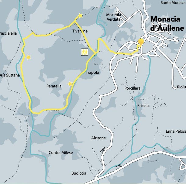
For a change from the coast, this inland loop starts from the village of Monacia d'Aullene and reaches the abandoned hamlets of Peratella and Tivarone. This is pastoral Corsica — dry-stone huts, terraces once cultivated, century-old cork oaks. You meet more free-roaming Corsican pigs than tourists.
The walk is quite unlike anything else in our selection. It tells of another Corsica: of transhumance, of upland farms, of silence.
— Our advice
Combine it with lunch at the Auberge de Monacia d'Aullene: Corsican family cooking, local produce, gentle prices. Walkable in any season, and cooler than the coast.
Our summary at a glance
| # | Hiking | Difficulty | Time | From Figari |
|---|---|---|---|---|
| 01 | The Canni path | Easy | 1h30 | 5 min |
| 02 | The Ventilegna path | Moderate | 4h | 15 min |
| 03 | The Bruzzi path | Easy | 2h | 15 min |
| 04 | The Omu di Cagna | Strenuous | 6h | 30 min |
| 05 | Rondinara bay | Very easy | 1h | 25 min |
| 06 | Palombaggia — Pruna | Easy | 1h30 | 25 min |
| 07 | Tamariccio — Colombara | Easy | 1h30 | 25 min |
| 08 | Tour d'Olmeto | Moderate | 3h | 25 min |
| 09 | The Peratella loop | Moderate | 2h30 | 30 min |
Our 3 favourites for a first visit
If this is your first stay in the area and you want the three unmissable walks :
- The Bruzzi — for the postcard landscape, doable with a family
- La Rondinara bay — for a breathtaking view in an hour's walk
- The Ventilegna path — for a proper full-day coastal walk
The others will come on a second visit. You will inevitably want one.